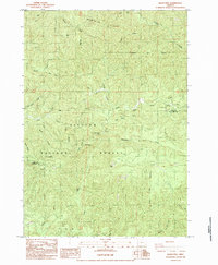
1984 Map of Baldy Mtn
USGS Topo · Published 1984About this map
Baldy Mtn rises above a landscape dominated by the Siuslaw Nat For, where the upper reaches of the North Fork Smith River and Middle Fk Smith River converge near the Lane Co Douglas Co line. This 1984 provisional survey illustrates a managed forest landscape, defined by a network of logging roads and resource extraction sites such as the Quarry near North Fork Falls. The drainage patterns are complex, with steep-walled canyons like South Canyon and prominent ridges such as Hand Ridge dividing various tributaries. Small-scale industrial activity is evidenced by scattered sites like the Barrow Pit and Gravel Pit, reflecting the area's timber and infrastructure needs in the late 20th century. High points including Mt Grayback and Table Rock serve as landmarks within the dense canopy, while named waterways like Sweet Creek and Kentucky Creek carve through the deep terrain of the Oregon Coast Range.
Find a feature on this map
27 named features on this map. Tap any name to fly to it.
Don’t see what you’re looking for? This feature index may not catch every label — zoom into the map to look around manually.
Map Details
Editions of this 1984 Baldy Mtn Map
This is the sole edition of this map. No revisions or reprints were ever made.
Other maps of this area

1918 · Mapleton
USGS Topo · 1:48,000

1919 · Earl
USGS Topo · 1:48,000

1940 · Mapleton
USGS Topo · 1:62,500

1941 · Blachly
USGS Topo · 1:62,500

1942 · Blachly
USGS Topo · 1:62,500

1942 · Roman Nose Mtn
USGS Topo · 1:62,500

1943 · Goodwin Peak
USGS Topo · 1:62,500

1945 · Mapleton
USGS Topo · 1:62,500

1945 · Roman Nose Mtn
USGS Topo · 1:62,500

1953 · Salem
USGS Topo · 1:250,000