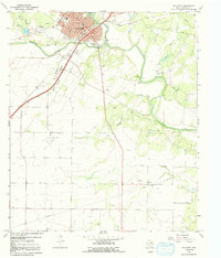
1967 Map of Ballinger
USGS Topo · Published 1992About this map
Ballinger sits at the strategic confluence of the Colorado River and Elm Creek in Central Texas, serving as a regional hub of transportation and civic life during the late 1960s. The town grid is anchored by the Courthouse, City Hall, and the Armory, while industrial and aviation activity is marked by numerous Gravel Pits and the Middleton Landing Strip. Beyond the residential streets, the landscape transitions into a series of smaller watercourses like Pony Creek and Spur Creek, where the rural community of Bethel and landmarks like the Drive-in Theater highlight the area's mid-century character. Notable local history sites include the Evergreen Cem and Bruce Field, providing researchers with clear evidence of established family lineages and infrastructure in Runnels County.
Find a feature on this map
36 named features on this map. Tap any name to fly to it.
Don’t see what you’re looking for? This feature index may not catch every label — zoom into the map to look around manually.
Map Details
Editions of this 1967 Ballinger Map
2 editions found
Other maps of this area

1891 · Hayrick
USGS Topo · 1:125,000

1892 · Ballinger
USGS Topo · 1:125,000

1894 · Hayrick
USGS Topo · 1:125,000

1921 · Hatchel
USGS Topo · 1:31,680

1921 · Lowake
USGS Topo · 1:31,680

1921 · Quarry Creek
USGS Topo · 1:31,680

1921 · Spur Creek
USGS Topo · 1:31,680

1921 · Rowena
USGS Topo · 1:31,680

1925 · Ballinger 3-d
USGS Topo · 1:48,000

1932 · Paint Rock
USGS Topo · 1:62,500