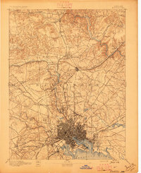
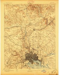
1894 Map of Baltimore
USGS Topo · Published 1896About this map
Ft. Mc. Henry stands as a prominent sentinel at the entrance to the North West Harbor, anchoring a landscape where the dense urban grid of Baltimore City gives way to the burgeoning suburbs and industrial outskirts of the late 19th century. The map illustrates a region in transit, dominated by the radial sweep of turnpikes like the York Turnpike and Reisterstown Turnpike alongside a complex web of railroads including the Northern Central Railroad and the Baltimore and Ohio R.R. To the north, the industrial character is defined by the Marble Quarries near Cockeysville and Texas, while the institutional growth of the era is evident at the Sheppard Asylum and Notre Dame. The winding courses of Jones Falls and Gunpowder Falls provide the hydrological backbone for the region's development, fueling early industry and necessitating the creation of reservoirs like Lake Roland and Loch Raven.
Find a feature on this map
120 named features on this map. Tap any name to fly to it.
Don’t see what you’re looking for? This feature index may not catch every label — zoom into the map to look around manually.
Map Details
Editions of this 1894 Baltimore Map
3 editions found
Other maps of this area

1892 · Laurel
USGS Topo · 1:62,500

1892 · Ellicott
USGS Topo · 1:62,500

1893 · North Point
USGS Topo · 1:62,500

1893 · Gunpowder
USGS Topo · 1:62,500

1894 · Ellicott
USGS Topo · 1:62,500

1894 · Laurel
USGS Topo · 1:62,500

1894 · Baltimore
USGS Topo · 1:62,500

1894 · Relay
USGS Topo · 1:62,500

1897 · Laurel
USGS Topo · 1:62,500

1898 · Tolchester
USGS Topo · 1:125,000