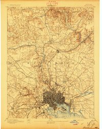
1894 Map of Baltimore
USGS Topo · Published 1897About this map
North West Harbor and the Patapsco River anchor this late 19th-century portrait of a growing industrial and residential landscape. The dense urban grid of Baltimore contrasts with the outlying villages and institutional grounds that defined the era. Notable landmarks such as Ft.Mc.Henry and Lazaretto Lt. guard the harbor entrance, while the interior is marked by significant healthcare and education sites like Sheppard Asylum and Notre Dame.
Find a feature on this map
124 named features on this map. Tap any name to fly to it.
Don’t see what you’re looking for? This feature index may not catch every label — zoom into the map to look around manually.
Map Details
Editions of this 1894 Baltimore Map
3 editions found
Other maps of this area

1892 · Laurel
USGS Topo · 1:62,500

1892 · Ellicott
USGS Topo · 1:62,500

1893 · North Point
USGS Topo · 1:62,500

1893 · Gunpowder
USGS Topo · 1:62,500

1894 · Ellicott
USGS Topo · 1:62,500

1894 · Laurel
USGS Topo · 1:62,500

1894 · Baltimore
USGS Topo · 1:62,500

1894 · Relay
USGS Topo · 1:62,500

1897 · Laurel
USGS Topo · 1:62,500

1898 · Tolchester
USGS Topo · 1:125,000