
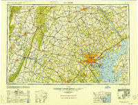
1948 Map of Baltimore
USGS Topo · Published 1948About this map
Baltimore anchors this expansive post-war survey, which spans from the industrial shoreline of the Chesapeake Bay to the ridges of the Blue Ridge mountains. In the years following World War II, the region's heavy reliance on rail and maritime transport is evident in the dense network of lines including the Pennsylvania RR and Baltimore & Ohio RR. Military readiness is a defining theme, with sprawling installations like the Aberdeen Proving Ground, Edgewood Arsenal, and Fort George Meade Military Reservation occupying significant acreage along the coastal and inland corridors.
Find a feature on this map
279 named features on this map. Tap any name to fly to it.
Don’t see what you’re looking for? This feature index may not catch every label — zoom into the map to look around manually.
Map Details
Editions of this 1948 Baltimore Map
2 editions found
Other maps of this area

1884 · Harpers Ferry
USGS Topo · 1:125,000

1890 · Mt. Vernon
USGS Topo · 1:125,000

1891 · Harpers Ferry
USGS Topo · 1:125,000

1891 · Mt. Vernon
USGS Topo · 1:125,000

1892 · Laurel
USGS Topo · 1:62,500

1892 · Ellicott
USGS Topo · 1:62,500

1892 · Owensville
USGS Topo · 1:62,500

1892 · Annapolis
USGS Topo · 1:62,500

1893 · North Point
USGS Topo · 1:62,500

1893 · Gunpowder
USGS Topo · 1:62,500