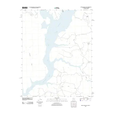
2010 Map of Bancos Mesa NW
USGS Topo · Published 2010About this map
Navajo Reservoir dominates this high-desert landscape in San Juan County, where the sprawling water body fills the branching valleys of the San Juan River basin. The 2010 shoreline is traced in detail, showing the intricate finger-like inlets created by Cottonwood Canyon and Eul Canyon. Aviation infrastructure is represented by the Navajo Landing Strip on the northern plateau, while agricultural history persists through the alignment of the Miller Ditch. High mesas define the horizon, including Carracas Mesa and Quintana Mesa, bordering the complex drainage systems of Cabresto Creek and the southern Laguna Seca Draw. The map documents a rugged network of rural routes, such as County Hwy 527 and Carracas Mesa Rd, which provide access to these remote tablelands and the settlement area of Bancos.
Find a feature on this map
19 named features on this map. Tap any name to fly to it.
Don’t see what you’re looking for? This feature index may not catch every label — zoom into the map to look around manually.
Map Details
Editions of this 2010 Bancos Mesa NW Map
This is the sole edition of this map. No revisions or reprints were ever made.
Other maps of this area

1889 · Largo
USGS Topo · 1:250,000

1895 · Largo
USGS Topo · 1:250,000

1908 · Ignacio
USGS Topo · 1:125,000

1924 · Ignacio
USGS Topo · 1:125,000

1924 · Pagosa Springs
USGS Topo · 1:125,000

1927 · Pagosa Springs
USGS Topo · 1:125,000

1945 · Durango
USGS Topo · 1:250,000

1953 · Durango
USGS Topo · 1:250,000

1954 · Durango
USGS Topo · 1:250,000

1954 · Allison
USGS Topo · 1:24,000