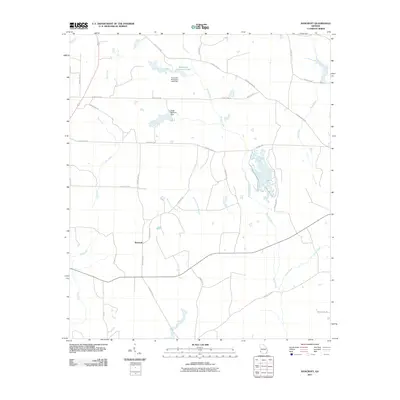
2011 Map of Bancroft
USGS Topo · Published 2011About this map
Bancroft serves as the primary settlement hub in this Early County landscape, where the agricultural legacy of Southwest Georgia is reflected in the naming of Kolomoki Plantation Lake. The terrain is defined by a dense network of watercourses, with Spring Creek and Perry Creek providing the principal drainage for the region's cultivated fields. Water management is a visible priority here, evidenced by engineered features like the Kolomoki Plantation Lake Dam and the Ralph Balkcom Dam. The rural infrastructure is maintained through a grid of numbered county roads, such as County Rd-282 and John McMurria Rd, which connect remote farmsteads to the center at Bancroft. Smaller tributaries like Number Five Branch and Number Seven Branch weave through the acreage, illustrating the fine-grained hydrology of the coastal plain.
Find a feature on this map
32 named features on this map. Tap any name to fly to it.
Don’t see what you’re looking for? This feature index may not catch every label — zoom into the map to look around manually.
Map Details
Editions of this 2011 Bancroft Map
This is the sole edition of this map. No revisions or reprints were ever made.
Other maps of this area

1953 · Dothan
USGS Topo · 1:250,000

1954 · Dothan
USGS Topo · 1:250,000

1955 · Dothan
USGS Topo · 1:250,000

1973 · Blakely North
USGS Topo · 1:24,000

1973 · Bancroft
USGS Topo · 1:24,000

1973 · Blakely South
USGS Topo · 1:24,000

1973 · Edison
USGS Topo · 1:24,000
1973 · Bluffton
USGS Topo · 1:24,000
1973 · Zetto
USGS Topo · 1:24,000

1973 · Hentown
USGS Topo · 1:24,000