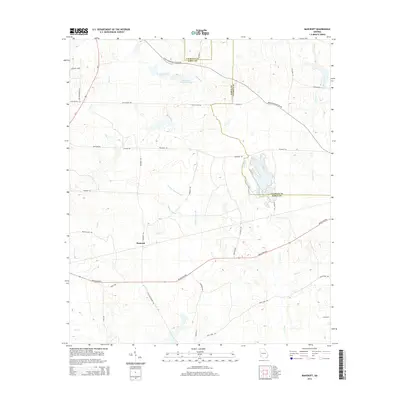
2014 Map of Bancroft
USGS Topo · Published 2014About this map
Bancroft and its surrounding agricultural landscape define this portion of southwest Georgia, situated along the border of Early and Calhoun counties. The terrain is marked by a complex network of tributaries, including the southern-flowing Spring Creek and the meandering Dry Cr to the west. Central to the drainage pattern is the Kolomoki Plantation Lake, which feeds into Lee Branch. The road system reflects the rural character of the era, with family-named routes such as Giles-Hightower Rd, McKnight Rd, and Jack Slaton Rd connecting scattered farmsteads. To the south, the Arlington Hwy serves as a primary east-west thoroughfare, while smaller lanes like Zion Washington Ln and Christ Missionary Church Rd suggest long-established community centers and local congregations that have shaped the social geography of the region.
Find a feature on this map
40 named features on this map. Tap any name to fly to it.
Don’t see what you’re looking for? This feature index may not catch every label — zoom into the map to look around manually.
Map Details
Editions of this 2014 Bancroft Map
This is the sole edition of this map. No revisions or reprints were ever made.
Other maps of this area

1953 · Dothan
USGS Topo · 1:250,000

1954 · Dothan
USGS Topo · 1:250,000

1955 · Dothan
USGS Topo · 1:250,000

1973 · Blakely North
USGS Topo · 1:24,000

1973 · Bancroft
USGS Topo · 1:24,000

1973 · Blakely South
USGS Topo · 1:24,000

1973 · Edison
USGS Topo · 1:24,000
1973 · Bluffton
USGS Topo · 1:24,000
1973 · Zetto
USGS Topo · 1:24,000

1973 · Hentown
USGS Topo · 1:24,000