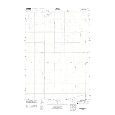
2012 Map of Bancroft East
USGS Topo · Published 2012About this map
Redstone Cr meanders southward through this Kingsbury County landscape, defining the local drainage patterns between a strictly organized grid of township roads. The map highlights a rural agricultural region where large-scale prairie hydrology is evident in the presence of Spirit Lake at the northeastern corner and Lake Agnew further west. These water bodies, along with smaller unnamed seasonal wetlands, are typical of the glacial pothole region of South Dakota. The transportation network is built upon long-established section lines, with major thoroughfares like Main Ave and Cottonwood Ave providing the primary north-south axes. Near Lake Agnew, the grid adapts slightly with local designations like Lake Agnew Pl, suggesting the localized importance of the lakefront for residents or seasonal visitors in an otherwise uniform landscape of farm plots.
Find a feature on this map
21 named features on this map. Tap any name to fly to it.
Don’t see what you’re looking for? This feature index may not catch every label — zoom into the map to look around manually.
Map Details
Editions of this 2012 Bancroft East Map
This is the sole edition of this map. No revisions or reprints were ever made.
Other maps of this area

1899 · De Smet
USGS Topo · 1:125,000

1953 · Watertown
USGS Topo · 1:250,000

1958 · Watertown
USGS Topo · 1:250,000

1971 · Iroquois
USGS Topo · 1:24,000

1971 · Bancroft East
USGS Topo · 1:24,000

1971 · De Smet
USGS Topo · 1:24,000

1971 · Bancroft West
USGS Topo · 1:24,000

1971 · De Smet SE
USGS Topo · 1:24,000
1971 · Manchester
USGS Topo · 1:24,000

1973 · Carpenter SE
USGS Topo · 1:24,000
Featured Places
- Bancroft, SD
- Manchester Township, SD
- Spirit Lake Township, SD
- Le Sueur Township, SD
- Kingsbury County, SD