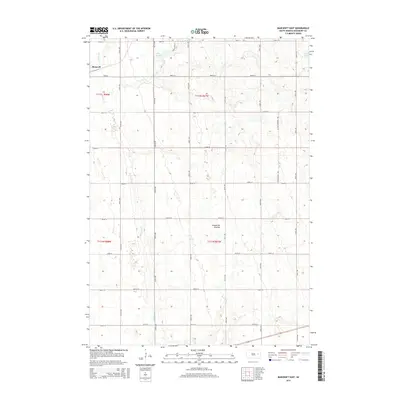
2015 Map of Bancroft East
USGS Topo · Published 2015About this map
Bancroft occupies the northwestern corner of this Kingsbury County landscape, where the flat agricultural grid of eastern South Dakota meets the distinct glacial geography of the Coteau des Prairies. This highland plateau creates a terrain of numerous small depressions and basins, as evidenced by the winding path of Redstone Cr and isolated bodies of water like Lake Agnew and Spirit Lake. The map details a strictly organized section-line road system, including Cottonwood Ave and a series of numbered avenues and streets that define the rural township structure. This 2015 survey provides a modern record of land divisions and hydrologic features in a region defined by its glacial history and prairie heritage.
Find a feature on this map
25 named features on this map. Tap any name to fly to it.
Don’t see what you’re looking for? This feature index may not catch every label — zoom into the map to look around manually.
Map Details
Editions of this 2015 Bancroft East Map
This is the sole edition of this map. No revisions or reprints were ever made.
Other maps of this area

1899 · De Smet
USGS Topo · 1:125,000

1953 · Watertown
USGS Topo · 1:250,000

1958 · Watertown
USGS Topo · 1:250,000

1971 · Iroquois
USGS Topo · 1:24,000

1971 · Bancroft East
USGS Topo · 1:24,000

1971 · De Smet
USGS Topo · 1:24,000

1971 · Bancroft West
USGS Topo · 1:24,000

1971 · De Smet SE
USGS Topo · 1:24,000
1971 · Manchester
USGS Topo · 1:24,000

1973 · Carpenter SE
USGS Topo · 1:24,000
Featured Places
- Bancroft, SD
- Manchester Township, SD
- Spirit Lake Township, SD
- Le Sueur Township, SD
- Kingsbury County, SD