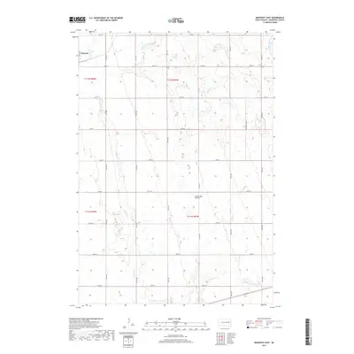
2017 Map of Bancroft East
USGS Topo · Published 2017About this map
The settlement of Bancroft anchors the northwest corner of this eastern Kingsbury County landscape, situated within the distinctive geologic region of the Coteau des Prairies. This highland plateau, which rises above the surrounding plains, is characterized here by a dense network of prairie potholes and small wetlands typical of the glacial till plains. Water features include Lake Agnew and the meandering path of Redstone Cr, which winds southward through the center of the survey. The grid-based road network, including corridors like Cottonwood Ave and Main Ave, defines the agricultural sections of Le Sueur Township. This 2017 survey reflects the persistent rural character of the region, where drainage patterns and topographic relief dictate the placement of local homesteads and farm-to-market routes across the glacial landscape.
Find a feature on this map
25 named features on this map. Tap any name to fly to it.
Don’t see what you’re looking for? This feature index may not catch every label — zoom into the map to look around manually.
Map Details
Editions of this 2017 Bancroft East Map
This is the sole edition of this map. No revisions or reprints were ever made.
Other maps of this area

1899 · De Smet
USGS Topo · 1:125,000

1953 · Watertown
USGS Topo · 1:250,000

1958 · Watertown
USGS Topo · 1:250,000

1971 · Iroquois
USGS Topo · 1:24,000

1971 · Bancroft East
USGS Topo · 1:24,000

1971 · De Smet
USGS Topo · 1:24,000

1971 · Bancroft West
USGS Topo · 1:24,000

1971 · De Smet SE
USGS Topo · 1:24,000
1971 · Manchester
USGS Topo · 1:24,000

1973 · Carpenter SE
USGS Topo · 1:24,000
Featured Places
- Bancroft, SD
- Manchester Township, SD
- Spirit Lake Township, SD
- Le Sueur Township, SD
- Kingsbury County, SD