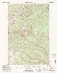
1995 Map of Bandbox Mountain
USGS Topo · Published 1997About this map
Old Yogo Town (Site) sits at the heart of this mid-1990s survey, marking a historical footprint within the Lewis and Clark National Forest. The landscape is defined by its deep mining history, evidenced by a prominent strip mine and numerous scattered prospects found across the drainages of Yogo Creek and Sage Creek. The high-altitude terrain is anchored by massive formations like Bandbox Mountain and Tucken Mountain, with narrow watercourses such as Republican Gulch and Flat Gulch cutting through the slopes. This map documents a region where the legacy of extraction meets preserved forest land, showing the transition from early settlement sites to late-20th-century resource management. Detailed drainage patterns from Running Wolf Cr and the various forks of the local creek systems provide a clear view of the complex hydrology of the Judith Basin area.
Find a feature on this map
34 named features on this map. Tap any name to fly to it.
Don’t see what you’re looking for? This feature index may not catch every label — zoom into the map to look around manually.
Map Details
Editions of this 1995 Bandbox Mountain Map
This is the sole edition of this map. No revisions or reprints were ever made.
Other maps of this area

1886 · Little Belt Mts.
USGS Topo · 1:250,000

1890 · Fort Benton
USGS Topo · 1:250,000

1892 · Fort Benton
USGS Topo · 1:250,000

1894 · Little Belt Mts.
USGS Topo · 1:250,000

1897 · Fort Benton
USGS Topo · 1:250,000

1897 · Little Belt Mts.
USGS Topo · 1:250,000

1898 · Little Belt Mts.
USGS Topo · 1:250,000

1902 · Little Belt Mts.
USGS Topo · 1:250,000

1948 · White Sulphur Springs
USGS Topo · 1:250,000

1954 · Great Falls
USGS Topo · 1:250,000