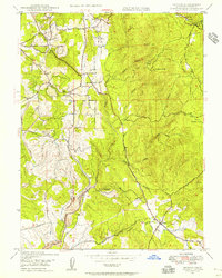
1947 Map of Bangor
USGS Topo · Published 1956About this map
Wyandotte and the outlying community of Hurleton anchor this 1947 topographical record of the foothills southeast of Oroville. The landscape is defined by the complex drainage of North Honcut Creek and its many tributaries, including Fine Gold Gulch and Rocky Honcut Creek. Evidence of the region’s hydraulic and hard-rock history is prominent, with the Phoenix Mine (Abandoned) and Blue Lead Mine (Abandoned) situated among hills like Katskill Hill and Phoenix Hill. The presence of the Palermo Canal and various siphons indicates the sophisticated water management required for local industry and agriculture during this era. Genealogists will find interest in the Oak Grove Cem near Hurleton, while the inclusion of a Sawmill and the settlement at Swedes Flat reveals a rural economy still deeply tied to timber and small-scale resource extraction.
Find a feature on this map
32 named features on this map. Tap any name to fly to it.
Don’t see what you’re looking for? This feature index may not catch every label — zoom into the map to look around manually.
Map Details
Editions of this 1947 Bangor Map
4 editions found
Other maps of this area

1888 · Marysville
USGS Topo · 1:125,000

1888 · Smartsville
USGS Topo · 1:125,000

1888 · Bidwell Bar
USGS Topo · 1:125,000

1891 · Bidwell Bar
USGS Topo · 1:125,000

1891 · Chico
USGS Topo · 1:125,000

1891 · Marysville
USGS Topo · 1:125,000

1891 · Smartsville
USGS Topo · 1:125,000

1892 · Smartsville
USGS Topo · 1:125,000

1893 · Chico
USGS Topo · 1:125,000

1893 · Bidwell Bar
USGS Topo · 1:125,000