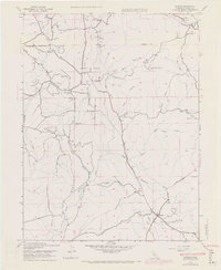
1947 Map of Bangor
USGS Topo · Published 1971About this map
The settlement of Bangor serves as a focal point in this 1947 study of the foothills southeast of Oroville, where the landscape is defined by the legacy of hydraulic mining and early water management. A complex network of water conveyance structures including the Palermo Canal, the Sawmill Ditch, and several Siphon and Flume segments trace the contours of the land, illustrating the massive engineering efforts required to redirect water for gold extraction and agriculture. Historic mining activity is documented at the Blue Lead Mine (Abandoned) and Phoenix Mine (Abandoned), pointing to the area's extraction-heavy economy.
Find a feature on this map
38 named features on this map. Tap any name to fly to it.
Don’t see what you’re looking for? This feature index may not catch every label — zoom into the map to look around manually.
Map Details
Editions of this 1947 Bangor Map
4 editions found
Other maps of this area

1888 · Marysville
USGS Topo · 1:125,000

1888 · Smartsville
USGS Topo · 1:125,000

1888 · Bidwell Bar
USGS Topo · 1:125,000

1891 · Bidwell Bar
USGS Topo · 1:125,000

1891 · Chico
USGS Topo · 1:125,000

1891 · Marysville
USGS Topo · 1:125,000

1891 · Smartsville
USGS Topo · 1:125,000

1892 · Smartsville
USGS Topo · 1:125,000

1893 · Chico
USGS Topo · 1:125,000

1893 · Bidwell Bar
USGS Topo · 1:125,000