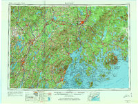
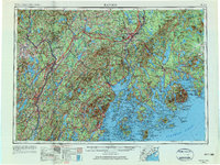
1956 Map of Bangor
USGS Topo · Published 1973About this map
The Penobscot River and Kennebec River anchor this mid-century portrait of coastal and central Maine, illustrating the established maritime and industrial corridors of the 1950s. Urban centers like Bangor, Augusta, and Waterville serve as regional hubs connected by a dense network of roads and the Maine Central RR, while smaller coastal towns such as Belfast and Rockland maintain their maritime orientation along Penobscot Bay.
Find a feature on this map
71 named features on this map. Tap any name to fly to it.
Don’t see what you’re looking for? This feature index may not catch every label — zoom into the map to look around manually.
Map Details
Editions of this 1956 Bangor Map
3 editions found

Other maps of this area

1892 · Gardiner
USGS Topo · 1:62,500

1892 · Freeport
USGS Topo · 1:62,500

1892 · Waterville
USGS Topo · 1:62,500

1892 · Augusta
USGS Topo · 1:62,500

1893 · Vassalboro
USGS Topo · 1:62,500

1893 · Wiscasset
USGS Topo · 1:62,500

1893 · Boothbay
USGS Topo · 1:62,500

1894 · Norridgewock
USGS Topo · 1:62,500

1894 · Bath
USGS Topo · 1:62,500

1898 · Norridgewock
USGS Topo · 1:62,500