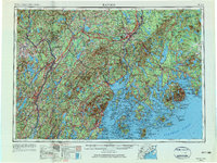
1956 Map of Bangor
USGS Topo · Published 1984About this map
The Penobscot River and Kennebec River define the industrial and maritime character of this mid-coast region during the mid-1950s. Centered on the hub of Bangor and its neighbor Brewer, the map reveals a landscape still heavily reliant on rail transport, featuring the extensive networks of the Maine Central RR and the Bangor & Aroostook RR. To the south, the intricate coastline of Penobscot Bay and Blue Hill Bay gives way to the prominent peaks of Mount Desert Island, where Acadia National Park preserves the rocky shore near Bar Harbor. The presence of Dow Air Force Base near the regional center highlights the era's strategic military footprint amidst traditional logging and milling towns like Old Town and Skowhegan. This survey captures the transition from river-based industry to a post-war economy shaped by federal installations and coastal tourism.
Find a feature on this map
50 named features on this map. Tap any name to fly to it.
Don’t see what you’re looking for? This feature index may not catch every label — zoom into the map to look around manually.
Map Details
Editions of this 1956 Bangor Map
3 editions found

Other maps of this area

1892 · Gardiner
USGS Topo · 1:62,500

1892 · Freeport
USGS Topo · 1:62,500

1892 · Waterville
USGS Topo · 1:62,500

1892 · Augusta
USGS Topo · 1:62,500

1893 · Vassalboro
USGS Topo · 1:62,500

1893 · Wiscasset
USGS Topo · 1:62,500

1893 · Boothbay
USGS Topo · 1:62,500

1894 · Norridgewock
USGS Topo · 1:62,500

1894 · Bath
USGS Topo · 1:62,500

1898 · Norridgewock
USGS Topo · 1:62,500