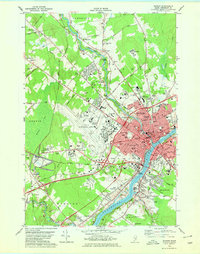
1978 Map of Bangor
USGS Topo · Published 1979About this map
The Penobscot River separates the commercial and industrial hubs of Bangor and Brewer in this late-1970s survey. The landscape reflects a city in transition, where established rail corridors like the Maine Central Railroad and Bangor and Aroostook Railroad intersect with modern infrastructure. Significant aviation development is evident at Bangor International Airport, formerly Dow Air Force Base, which sits adjacent to the Northern Maine Junction. The city's cultural and academic life is anchored by Husson College and the Theological Seminary, while the Morse Covered Bridge remains a landmark over Kenduskeag Stream. Beyond the urban core, the terrain gives way to the ecologically distinct Hermon Bog and the agricultural fringes of Hampden and Glenburn.
Find a feature on this map
124 named features on this map. Tap any name to fly to it.
Don’t see what you’re looking for? This feature index may not catch every label — zoom into the map to look around manually.
Map Details
Editions of this 1978 Bangor Map
2 editions found
Other maps of this area

1900 · Orland
USGS Topo · 1:62,500

1900 · Bucksport
USGS Topo · 1:62,500

1902 · Orono
USGS Topo · 1:62,500

1902 · Bucksport
USGS Topo · 1:62,500

1902 · Bangor
USGS Topo · 1:62,500

1942 · Orland
USGS Topo · 1:62,500

1942 · Bangor
USGS Topo · 1:62,500

1942 · Bucksport
USGS Topo · 1:62,500

1944 · Orono
USGS Topo · 1:62,500

1946 · Bangor
USGS Topo · 1:62,500