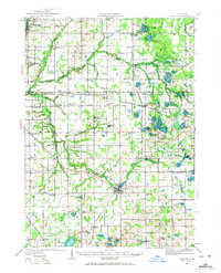
1927 Map of Bangor
USGS Topo · Published 1972About this map
Bangor serves as a central hub on this 1927 survey, situated at the confluence of rail and water where the Pere Marquette RR crosses the South Fork Black River near the Mill Pond. The landscape of northern Van Buren and southern Allegan counties is defined by a dense network of country schools, many named for local families or landmarks, such as the Garden of Eden Sch, Evergreen Glade Sch, and Maple Grove Sch. These school districts, spaced every few miles, reveal the high population density of this fruit-belt region before the consolidation of rural education.
Find a feature on this map
114 named features on this map. Tap any name to fly to it.
Don’t see what you’re looking for? This feature index may not catch every label — zoom into the map to look around manually.
Map Details
Editions of this 1927 Bangor Map
2 editions found
Other maps of this area

1927 · Hartford
USGS Topo · 1:62,500

1927 · Bangor
USGS Topo · 1:62,500

1927 · Benton Harbor
USGS Topo · 1:62,500

1927 · South Haven
USGS Topo · 1:62,500

1928 · Fennville
USGS Topo · 1:62,500

1930 · South Haven
USGS Topo · 1:62,500

1930 · Benton Harbor
USGS Topo · 1:62,500

1931 · Fennville
USGS Topo · 1:62,500

1931 · Bangor
USGS Topo · 1:62,500

1931 · Hartford
USGS Topo · 1:62,500