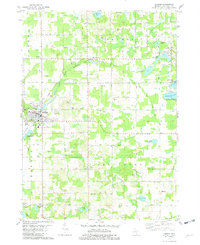
1981 Map of Bangor
USGS Topo · Published 1982About this map
The Black River and its South Branch Black River define the agricultural and lacustrine landscape of this Van Buren County region in the early 1980s. The city of Bangor serves as a central hub, where the Chesapeake and Ohio railroad cuts through the terrain near the Sacred Heart Ch and the local High Sch. To the north, the village of Breedsville sits along the riverbank, surrounded by a high density of specialized agriculture and small water bodies. The map reveals a deeply rooted rural community, marked by numerous small cemeteries such as Hoppin Cem, Coburn Cem, and Hicks Cem, alongside local institutions like the Arlington Center Sch. The landscape is dotted with varied glacial lakes, including the Upper Jeptha Lake and Lower Jeptha Lake systems, which appear alongside active resource extraction sites like Sandpits and Gravel Pits.
Find a feature on this map
57 named features on this map. Tap any name to fly to it.
Don’t see what you’re looking for? This feature index may not catch every label — zoom into the map to look around manually.
Map Details
Editions of this 1981 Bangor Map
This is the sole edition of this map. No revisions or reprints were ever made.
Other maps of this area

1927 · Hartford
USGS Topo · 1:62,500

1927 · Bangor
USGS Topo · 1:62,500

1931 · Bangor
USGS Topo · 1:62,500

1931 · Hartford
USGS Topo · 1:62,500

1943 · Bangor
USGS Topo · 1:62,500

1944 · Marcellus
USGS Topo · 1:62,500

1946 · Marcellus
USGS Topo · 1:62,500

1946 · Gobles
USGS Topo · 1:62,500

1948 · Gobles
USGS Topo · 1:62,500

1949 · Gobles
USGS Topo · 1:62,500