
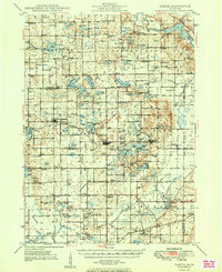
1949 Map of Gobles
USGS Topo · Published 1949About this map
Glacial geology and a robust agricultural economy define this post-war landscape across the Van Buren and Allegan county line. The New York Central railroad corridor anchors the settlements of Bloomingdale and Gobles, while the surrounding townships are densely dotted with dozens of small country schoolhouses like Wager Sch, Evergreen Sch, and Lindsley Sch. This era captures a region transitioning its land use, shown through several active Oil Wells scattered near Healy Sch and the development of the Wolf Lake Fish Hatchery and its associated Rearing Ponds in the southeast. Historical markers such as the Indian Cem near Chicora and the Pecktown Cem provide valuable evidence for genealogists, while the Paw Paw River and its various tributaries like Brandywine Creek and Swan Creek reveal the natural drainage patterns that dictated early road placement like Base Line Road.
Find a feature on this map
174 named features on this map. Tap any name to fly to it.
Don’t see what you’re looking for? This feature index may not catch every label — zoom into the map to look around manually.
Map Details
Editions of this 1949 Gobles Map
2 editions found
Other maps of this area

1916 · Kalamazoo
USGS Topo · 1:62,500

1918 · Kalamazoo
USGS Topo · 1:62,500

1922 · Schoolcraft
USGS Topo · 1:62,500

1927 · Hartford
USGS Topo · 1:62,500

1927 · Bangor
USGS Topo · 1:62,500

1928 · Fennville
USGS Topo · 1:62,500

1931 · Fennville
USGS Topo · 1:62,500

1931 · Bangor
USGS Topo · 1:62,500

1931 · Hartford
USGS Topo · 1:62,500

1943 · Kalamazoo
USGS Topo · 1:62,500