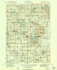
1949 Map of Gobles
USGS Topo · Published 1949About this map
Bloomingdale and Gobles serve as central hubs in this landscape of southwestern Michigan, where the post-war rural economy is defined by a dense network of country schools and small lakeside settlements. The region is characterized by an immense number of small water bodies, including Swan Lake, Eagle Lake, and the cluster near Mentha. This 1949 edition captures a period when local education was still decentralized, evidenced by the high density of rural schoolhouses such as Rowe Sch, Prouty Sch, and Evergreen Sch.
Find a feature on this map
137 named features on this map. Tap any name to fly to it.
Don’t see what you’re looking for? This feature index may not catch every label — zoom into the map to look around manually.
Map Details
Editions of this 1949 Gobles Map
2 editions found

Other maps of this area

1916 · Kalamazoo
USGS Topo · 1:62,500

1918 · Kalamazoo
USGS Topo · 1:62,500

1922 · Schoolcraft
USGS Topo · 1:62,500

1927 · Hartford
USGS Topo · 1:62,500

1927 · Bangor
USGS Topo · 1:62,500

1928 · Fennville
USGS Topo · 1:62,500

1931 · Fennville
USGS Topo · 1:62,500

1931 · Bangor
USGS Topo · 1:62,500

1931 · Hartford
USGS Topo · 1:62,500

1943 · Kalamazoo
USGS Topo · 1:62,500