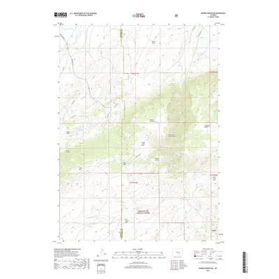
2018 Map of Banner Mountain
USGS Topo · Published 2018About this map
Medicine Bow National Forest dominates the southern landscape of this Natrona and Converse County border region, where the Laramie Range rises toward Banner Mountain. The terrain is defined by a series of deep cuts and grazing lands, including Lower Deer Creek Canyon and the high-elevation basin of Negro Creek Park. Water management is central to the area's geography, anchored by Rissler Reservoir and McDonald Reservoir, which support the drainages of Muddy Cr and Negro Cr. Local ranching and transit history is traced through named pastures like Steeple Pasture and Portuguese Pasture, alongside backroads such as Hat Six Rd and Cardine Rd that navigate the draws and canyons. The map preserves the specific nomenclature of the high plains, from the dramatic Trout Canyon to the wide Duck Creek Flats.
Find a feature on this map
43 named features on this map. Tap any name to fly to it.
Don’t see what you’re looking for? This feature index may not catch every label — zoom into the map to look around manually.
Map Details
Editions of this 2018 Banner Mountain Map
This is the sole edition of this map. No revisions or reprints were ever made.
Other maps of this area

1949 · Brookhurst
USGS Topo · 1:24,000

1949 · Parkerton
USGS Topo · 1:24,000

1950 · Lockett
USGS Topo · 1:24,000

1950 · Brookhurst
USGS Topo · 1:24,000

1950 · Parkerton
USGS Topo · 1:24,000

1954 · Torrington
USGS Topo · 1:250,000

1955 · Casper
USGS Topo · 1:250,000

1958 · Casper
USGS Topo · 1:250,000

1958 · Torrington
USGS Topo · 1:250,000

1960 · Ice Cave Mountain
USGS Topo · 1:24,000