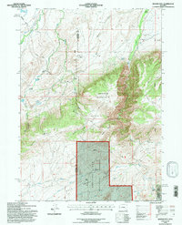
1992 Map of Banner Mtn
USGS Topo · Published 1996About this map
Banner Mountain dominates the high-elevation terrain where Converse Co and Natrona Co meet. This 1990s record of the high country shows a landscape defined by ranching and timber management, with large tracts of the Medicine Bow National Forest set against family-held ranch lands. The map details the local water system, including McDonald Reservoir and the State Ditch No 1, which reflect the region's reliance on irrigation for livestock. Settlement is sparse, consisting largely of named homesteads like the Smith Ranch, Kimball Ranch, and Kelly Ranch. The inclusion of the Banner Landing Strip and remote outposts like Brooks Camp illustrates the logistical challenges of managing this high-altitude pastureland. Notable topographical markers such as Steeple Hill and the deep cuts of Trout Creek Canyon provide a clear view of the drainage patterns toward Deer Creek.
Find a feature on this map
46 named features on this map. Tap any name to fly to it.
Don’t see what you’re looking for? This feature index may not catch every label — zoom into the map to look around manually.
Map Details
Editions of this 1992 Banner Mtn Map
This is the sole edition of this map. No revisions or reprints were ever made.
Other maps of this area

1949 · Brookhurst
USGS Topo · 1:24,000

1949 · Parkerton
USGS Topo · 1:24,000

1950 · Lockett
USGS Topo · 1:24,000

1950 · Brookhurst
USGS Topo · 1:24,000

1950 · Parkerton
USGS Topo · 1:24,000

1954 · Torrington
USGS Topo · 1:250,000

1955 · Casper
USGS Topo · 1:250,000

1958 · Casper
USGS Topo · 1:250,000

1958 · Torrington
USGS Topo · 1:250,000

1960 · Ice Cave Mountain
USGS Topo · 1:24,000