1943 Map of Banning
USGS Topo · Published 1952About this map
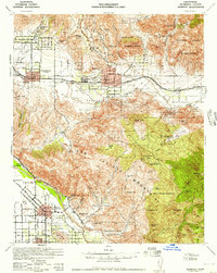
The San Gorgonio Pass serves as a critical corridor through the mountainous terrain of Riverside County, anchoring the growth of Banning and Beaumont during the mid-century. This survey, derived from 1940s road data and military photography, illustrates the heavy reliance on the Southern Pacific railroad and major thoroughfares like Pacific Ave to navigate the gap between the San Jacinto Mountains and the heights of the San Bernardino National Forest.
Find a feature on this map
82 named features on this map. Tap any name to fly to it.
Don’t see what you’re looking for? This feature index may not catch every label — zoom into the map to look around manually.
Map Details
Editions of this 1943 Banning Map
This is the sole edition of this map. No revisions or reprints were ever made.
Other maps of this area

1899 · Redlands
USGS Topo · 1:62,500

1901 · Southern California Sheet No. 1
USGS Topo · 1:250,000

1901 · San Jacinto
USGS Topo · 1:125,000

1901 · Redlands
USGS Topo · 1:62,500

1901 · Elsinore
USGS Topo · 1:125,000

1902 · San Gorgonio
USGS Topo · 1:125,000

1904 · Southern California Sheet No. 1
USGS Topo · 1:250,000

1940 · Palm Springs
USGS Topo · 1:62,500

1940 · Hemet Reservoir
USGS Topo · 1:62,500

1942 · Banning
USGS Topo · 1:62,500