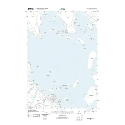
2011 Map of Bar Harbor
USGS Topo · Published 2011About this map
The coastal village of Bar Harbor serves as the gateway to the eastern reaches of Acadia National Park, where the rugged Maine shoreline meets the waters of Frenchman Bay. This early 21st-century record highlights the region's maritime character, tracing the Bar Harbor - Yarmouth ferry route and local nautical infrastructure like the Fisherman's Landing and Sorrento Town Wharf. The terrain is defined by a dense archipelago of named landforms, including The Porcupines and Stave Island, which protect the inner harbors from the open Atlantic. Inland, the map documents historical local landmarks such as the Meeting House and several family burying grounds, including Bragdon Cemetery and Hall Cemetery. From the settlements of Sorrento and Hancock Point in the north to the mountain-ringed basins of Eagle Lake and Witch Hole Pond in the south, the landscape reflects a balance between a working maritime economy and protected wilderness.
Find a feature on this map
117 named features on this map. Tap any name to fly to it.
Don’t see what you’re looking for? This feature index may not catch every label — zoom into the map to look around manually.
Map Details
Editions of this 2011 Bar Harbor Map
This is the sole edition of this map. No revisions or reprints were ever made.
Other maps of this area

1904 · Mount Desert
USGS Topo · 1:62,500

1904 · Bar Harbor
USGS Topo · 1:62,500

1911 · Ellsworth
USGS Topo · 1:62,500

1930 · Tunk Lake
USGS Topo · 1:48,000

1932 · Tunk Lake
USGS Topo · 1:62,500

1940 · Ellsworth
USGS Topo · 1:62,500

1942 · Bar Harbor
USGS Topo · 1:62,500

1942 · Ellsworth
USGS Topo · 1:62,500

1942 · Mount Desert
USGS Topo · 1:62,500

1942 · Tunk Lake
USGS Topo · 1:62,500