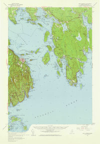
1956 Map of Bar Harbor
USGS Topo · Published 1960About this map
Acadia National Park dominates this mid-century coastal survey, illustrating the complex geography of Mount Desert Island and the surrounding Frenchman Bay. This era shows the well-established tourist infrastructure of Bar Harbor, including the Bar Harbor Ferry Terminal and the winding Park Loop Road which provides access to notable interior sites like Sieur de Monts Spring and the Abbe Museum. The map captures a moment before modern development altered many of these coastal enclaves, showing smaller settlements such as Gerrishville and South Gouldsboro in high detail. Across the bay, the Schoodic Peninsula remains remarkably isolated, featuring the U S Naval Res and the prominent Schoodic Head. To the south, the Cranberry Isles are clearly delineated, with the village of Islesford on Little Cranberry Island and the lonely light of Baker Island guarding the entrance to the harbor, reflecting the maritime reliance of these island communities.
Find a feature on this map
78 named features on this map. Tap any name to fly to it.
Don’t see what you’re looking for? This feature index may not catch every label — zoom into the map to look around manually.
Map Details
Editions of this 1956 Bar Harbor Map
3 editions found

Other maps of this area

1902 · Cherryfield
USGS Topo · 1:62,500

1904 · Cherryfield
USGS Topo · 1:62,500

1904 · Mount Desert
USGS Topo · 1:62,500

1904 · Swan Island
USGS Topo · 1:62,500

1904 · Bar Harbor
USGS Topo · 1:62,500

1904 · Petit Manan
USGS Topo · 1:62,500

1911 · Ellsworth
USGS Topo · 1:62,500

1930 · Tunk Lake
USGS Topo · 1:48,000

1932 · Tunk Lake
USGS Topo · 1:62,500

1940 · Ellsworth
USGS Topo · 1:62,500