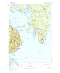
1956 Map of Bar Harbor
USGS Topo · Published 1967About this map
Frenchman Bay dominates this mid-century coastal survey, illustrating the complex geography of the Maine shoreline where Acadia National Park meets established seaside villages. The town of Bar Harbor serves as a central hub, with the Bar Harbor Ferry Terminal and numerous landings indicating the area's deep reliance on maritime travel. To the east, the Schoodic Peninsula Road traces the edge of the Winter Harbor peninsula, reaching landmarks like Schoodic Head and The Anvil.
Find a feature on this map
194 named features on this map. Tap any name to fly to it.
Don’t see what you’re looking for? This feature index may not catch every label — zoom into the map to look around manually.
Map Details
Editions of this 1956 Bar Harbor Map
3 editions found

Other maps of this area

1902 · Cherryfield
USGS Topo · 1:62,500

1904 · Cherryfield
USGS Topo · 1:62,500

1904 · Mount Desert
USGS Topo · 1:62,500

1904 · Swan Island
USGS Topo · 1:62,500

1904 · Bar Harbor
USGS Topo · 1:62,500

1904 · Petit Manan
USGS Topo · 1:62,500

1911 · Ellsworth
USGS Topo · 1:62,500

1930 · Tunk Lake
USGS Topo · 1:48,000

1932 · Tunk Lake
USGS Topo · 1:62,500

1940 · Ellsworth
USGS Topo · 1:62,500