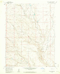
1960 Map of Bar J H Ranch
USGS Topo · Published 1962About this map
The high plains of eastern Pueblo County are defined by a complex network of arroyos and intermittent watercourses in this 1960 field-checked survey. Central to the landscape is the meandering path of Chico Creek, which is fed by numerous tributaries including Dry Creek, Burnt Creek, and the curiously named Tom Hollow. The map reveals the sparse ranching economy of the mid-twentieth century, dominated by established outfits like the Bar J H Ranch and May Ranch. Along the eastern edge, Black Squirrel Creek cuts through the terrain, illustrating the intricate drainage patterns that dictate land use in this arid region. This survey captures a specific moment in the rural West, documenting the relationship between scarce water sources like the isolated Spring and the positioning of ranching headquarters.
Find a feature on this map
10 named features on this map. Tap any name to fly to it.
Don’t see what you’re looking for? This feature index may not catch every label — zoom into the map to look around manually.
Map Details
Editions of this 1960 Bar J H Ranch Map
This is the sole edition of this map. No revisions or reprints were ever made.
Other maps of this area

1891 · Pueblo
USGS Topo · 1:125,000

1891 · Nepesta
USGS Topo · 1:125,000

1893 · Nepesta
USGS Topo · 1:125,000

1893 · Big Springs
USGS Topo · 1:125,000

1893 · Colorado Springs
USGS Topo · 1:125,000

1894 · Pueblo
USGS Topo · 1:125,000

1896 · Pueblo
USGS Topo · 1:125,000

1897 · Pueblo
USGS Topo · 1:125,000

1904 · Nepesta
USGS Topo · 1:125,000

1909 · Colorado Springs
USGS Topo · 1:125,000