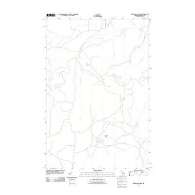
2011 Map of Baraga Plains
USGS Topo · Published 2011About this map
Baraga Plains dominates this landscape in Baraga County, defined by a complex network of waterways feeding the Upper Peninsula's watersheds. The area is characterized by a mix of upland plains and significant water features, including the notable Ogemaw Falls situated along Ogemaw Creek. The presence of the Prison Cp and Baraga Plains Rd indicates the human infrastructure supporting this relatively undeveloped region. Numerous creeks like Sixmile Creek, Menge Creek, and Nesters Creek carve through the terrain, punctuated by isolated bodies of water such as Engman Lake and Little Lake. This survey provides a clear view of the wilderness character and hydrology of the plains, where small lakes and named rapids like those on Ogemaw Creek serve as the primary landmarks.
Find a feature on this map
24 named features on this map. Tap any name to fly to it.
Don’t see what you’re looking for? This feature index may not catch every label — zoom into the map to look around manually.
Map Details
Editions of this 2011 Baraga Plains Map
This is the sole edition of this map. No revisions or reprints were ever made.
Other maps of this area

1954 · Keweenaw Bay
USGS Topo · 1:62,500

1954 · Pelkie
USGS Topo · 1:62,500

1954 · Sidnaw
USGS Topo · 1:62,500

1955 · Herman
USGS Topo · 1:62,500

1958 · Iron River
USGS Topo · 1:250,000

1960 · Iron River
USGS Topo · 1:250,000

1961 · Iron River
USGS Topo · 1:250,000

1967 · Iron River
USGS Topo · 1:250,000
1985 · L'Anse
USGS Topo · 1:24,000
1985 · Bear Town
USGS Topo · 1:24,000