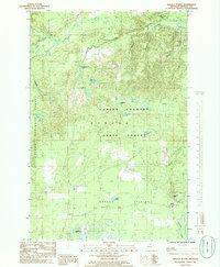
1985 Map of Baraga Plains
USGS Topo · Published 1986About this map
Copper Country State Forest and the Ottawa National Forest dominate this mid-1980s terrain in Michigan's Upper Peninsula. The landscape is defined by the Baraga Plains, a plateau characterized by glacial drainage patterns that feed into numerous small basins and creeks. Water is the primary feature of this interior wilderness, with systems like Ogemaw Creek leading to the distinctive Ogemaw Falls. Human presence is sparse but specific, centered on the Prison Farm and a scattered network of small lakes including Kelly Lake, Engman Lake, and Robillard Lake. The map reveals a transition between dense forest management and open plains, with several small waterways like Menge Creek and Leviture Creek carving through the northern sections of the forest.
Find a feature on this map
22 named features on this map. Tap any name to fly to it.
Don’t see what you’re looking for? This feature index may not catch every label — zoom into the map to look around manually.
Map Details
Editions of this 1985 Baraga Plains Map
This is the sole edition of this map. No revisions or reprints were ever made.
Other maps of this area

1954 · Keweenaw Bay
USGS Topo · 1:62,500

1954 · Pelkie
USGS Topo · 1:62,500

1954 · Sidnaw
USGS Topo · 1:62,500

1955 · Herman
USGS Topo · 1:62,500

1958 · Iron River
USGS Topo · 1:250,000

1960 · Iron River
USGS Topo · 1:250,000

1961 · Iron River
USGS Topo · 1:250,000

1967 · Iron River
USGS Topo · 1:250,000
1985 · L'Anse
USGS Topo · 1:24,000
1985 · Bear Town
USGS Topo · 1:24,000