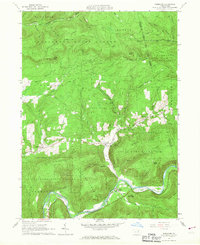
1965 Map of Barbours
USGS Topo · Published 1967About this map
Loyalsock Creek winds through the southern reaches of this mid-1960s Lycoming County landscape, where the small settlement of Barbours sits at the confluence of Plunketts Creek. The area is defined by a transition from the agricultural clearings around Proctor and Hoppestown to the dense, high-elevation woodlands of the Tiadaghton State Forest and State Game Lands No 134. Evidence of the region’s industrial past remains visible in the naming of the Old Pleasant Stream Railroad Road and the tucked-away Coal Mine Hollow.
Find a feature on this map
51 named features on this map. Tap any name to fly to it.
Don’t see what you’re looking for? This feature index may not catch every label — zoom into the map to look around manually.
Map Details
Editions of this 1965 Barbours Map
2 editions found
Other maps of this area

1927 · Eagles Mere
USGS Topo · 1:48,000

1930 · Warrensville
USGS Topo · 1:62,500

1932 · Eagle Mere
USGS Topo · 1:62,500

1934 · Warrensville
USGS Topo · 1:62,500

1942 · Canton
USGS Topo · 1:62,500

1943 · Powell
USGS Topo · 1:62,500

1944 · Canton
USGS Topo · 1:62,500

1945 · Powell
USGS Topo · 1:62,500

1953 · Warrensville
USGS Topo · 1:62,500

1953 · Eagles Mere
USGS Topo · 1:62,500
Featured Places
- Hillsgrove Township, PA
- Proctor, Plunketts Creek Township
- Wallis Run, Cascade Township
- Plunketts Creek Township, PA
- Fox Township, PA