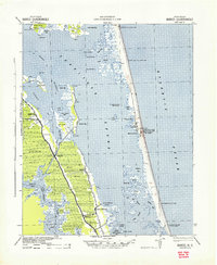
1940 Map of Barco
USGS Topo · Published 1940About this map
The Inland Waterway bisects the mainland and the Outer Banks in this 1940 military survey, detailing a landscape where the Currituck Sound dominates the coastal geography. On the barrier island, the Currituck Beach Lighthouse and several Coast Guard stations, including Corolla C. G. Sta. 166 and Poyner Hill C. G. Sta, stand watch over the Atlantic Ocean. The mainland is characterized by the expansive Great Swamp and a series of landings and small settlements like Coinjock and Poplar Branch that serve as vital nodes for sound-side activity.
Find a feature on this map
60 named features on this map. Tap any name to fly to it.
Don’t see what you’re looking for? This feature index may not catch every label — zoom into the map to look around manually.
Map Details
Editions of this 1940 Barco Map
2 editions found
Other maps of this area

1893 · Virginia Beach
USGS Topo · 1:125,000

1916 · Back Bay
USGS Topo · 1:62,500

1939 · Moyock
USGS Topo · 1:62,500

1940 · Barco
USGS Topo · 1:62,500

1940 · Kitty Hawk
USGS Topo · 1:62,500

1940 · Powells Point
USGS Topo · 1:62,500

1940 · Wade Point
USGS Topo · 1:62,500

1943 · Wade Point
USGS Topo · 1:62,500

1943 · Back Bay
USGS Topo · 1:62,500

1946 · Moyock
USGS Topo · 1:62,500