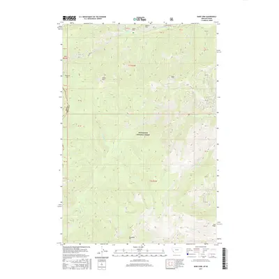
2017 Map of Bare Cone
USGS Topo · Published 2017About this map
Bitterroot National Forest dominates this high-altitude landscape along the border of Montana and Idaho, where the ridgeline separates the two states. The topography is defined by sharp peaks and deep drainage basins, anchored by landmarks such as Bare Cone, Castle Rock, and Razorback Mtn. To the north, Nezperce Pass provides a key transit point, accessible via the Nez Perce Rd which follows the path of the Nez Perce Fork. This region remains largely undeveloped, characterized by its network of watercourses including Blue Joint Creek and Little Blue Joint Creek. At Fales Flat, the terrain levels out briefly along the banks of Sheepherd Creek, offering a distinct break from the surrounding steep slopes. The map also documents the timber and resource management history of the area, with numerous forest service roads like FR 1303 winding through the timbered heights of Coal Ridge.
Find a feature on this map
44 named features on this map. Tap any name to fly to it.
Don’t see what you’re looking for? This feature index may not catch every label — zoom into the map to look around manually.
Map Details
Editions of this 2017 Bare Cone Map
This is the sole edition of this map. No revisions or reprints were ever made.
Other maps of this area

1956 · Elk City
USGS Topo · 1:250,000

1960 · Elk City
USGS Topo · 1:250,000

1960 · Painted Rocks Lake
USGS Topo · 1:62,500

1962 · Blue Joint
USGS Topo · 1:24,000

1962 · Nez Perce Peak
USGS Topo · 1:24,000

1964 · Boulder Peak
USGS Topo · 1:24,000
1964 · Mount Jerusalem
USGS Topo · 1:24,000

1966 · Watchtower Peak
USGS Topo · 1:24,000

1991 · Horse Creek Pass
USGS Topo · 1:24,000
1991 · Painted Rocks Lake
USGS Topo · 1:24,000