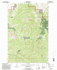
1995 Map of Barker
USGS Topo · Published 1997About this map
Hughesville and Barker sit deep in the forested canyons of the Little Belt Mountains on this mid-1990s survey. These settlements, located at the intersection of Dry Fork Belt Creek and McKay Gulch, reflect the area's industrial legacy within the Lewis and Clark National Forest. The landscape is dominated by high-altitude features like Sawmill Ridge and Hoover Ridge, while signs of mineral extraction remain visible through labels for a Mine and a Tailings Pond near the town sites. For genealogists and local historians, the Barker Cem provides a specific point of interest near the confluence of Gold Run Creek. The intricate drainage system, including Sawmill Creek and Spruce Creek, defines the narrow valleys where mining operations once concentrated on the border of Cascade and Judith Basin counties.
Find a feature on this map
57 named features on this map. Tap any name to fly to it.
Don’t see what you’re looking for? This feature index may not catch every label — zoom into the map to look around manually.
Map Details
Editions of this 1995 Barker Map
This is the sole edition of this map. No revisions or reprints were ever made.
Other maps of this area

1886 · Little Belt Mts.
USGS Topo · 1:250,000

1890 · Fort Benton
USGS Topo · 1:250,000

1892 · Fort Benton
USGS Topo · 1:250,000

1894 · Little Belt Mts.
USGS Topo · 1:250,000

1897 · Fort Benton
USGS Topo · 1:250,000

1897 · Little Belt Mts.
USGS Topo · 1:250,000

1898 · Little Belt Mts.
USGS Topo · 1:250,000

1902 · Little Belt Mts.
USGS Topo · 1:250,000

1948 · White Sulphur Springs
USGS Topo · 1:250,000

1954 · Great Falls
USGS Topo · 1:250,000