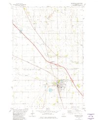
1981 Map of Barnesville
USGS Topo · Published 1981About this map
Barnesville serves as the focal point of this 1981 survey, positioned at the intersection of the Burlington Northern railroad lines and the boundary of Clay and Wilkin counties. The town's layout includes a Fairground, a Trailer Park, and the recreation area around Blue Eagle Lake. The surrounding prairie landscape is defined by the branching courses of Whisky Creek, Stony Creek, and Hay Creek, which drain the agricultural lands of Elkton and Humboldt townships. Genealogists will find significant value in the mapped locations of Rosemound, Elkton, and Norwegian cemeteries, alongside St Marys Ch. The presence of several Gravel Pits and the extensive State Wildlife Management Areas to the north highlight the dual local economy of resource extraction and land conservation during the early 1980s.
Find a feature on this map
29 named features on this map. Tap any name to fly to it.
Don’t see what you’re looking for? This feature index may not catch every label — zoom into the map to look around manually.
Map Details
Editions of this 1981 Barnesville Map
This is the sole edition of this map. No revisions or reprints were ever made.
Other maps of this area

1895 · Fargo
USGS Topo · 1:125,000

1897 · Fargo
USGS Topo · 1:125,000

1919 · Barnesville
USGS Topo · 1:62,500

1919 · Hawley
USGS Topo · 1:62,500

1952 · Barnesville
USGS Topo · 1:62,500

1953 · Fargo
USGS Topo · 1:250,000

1956 · Fargo
USGS Topo · 1:250,000

1964 · Baker
USGS Topo · 1:24,000
1964 · Glyndon South
USGS Topo · 1:24,000
1966 · Wolverton SE
USGS Topo · 1:24,000