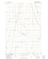
1981 Map of Barnesville SW
USGS Topo · Published 1981About this map
Deerhorn Creek meanders through the heart of this agricultural landscape in Wilkin County, revealing a territory defined by its complex drainage network and wildlife conservation efforts. The area is heavily managed by a series of engineered waterways, including Judicial Ditch No 14 and Judicial Ditch No 3-1, which segment the townships of Atherton, Prairie View, Manston, and Tanberg. Large tracts of land are preserved as the Atherton State Wildlife Management Area and the Rothsay State Wildlife Management Area, highlighting the region's commitment to natural habitat amidst surrounding farmland. The Burlington Northern railroad corridor cuts across the northeastern section, serving as a primary transportation artery near local landmarks like the Townhall and the South Branch Buffalo River. This 1981 survey documents the established section lines and property divisions that continue to shape rural Minnesota.
Find a feature on this map
19 named features on this map. Tap any name to fly to it.
Don’t see what you’re looking for? This feature index may not catch every label — zoom into the map to look around manually.
Map Details
Editions of this 1981 Barnesville SW Map
This is the sole edition of this map. No revisions or reprints were ever made.
Other maps of this area

1895 · Fargo
USGS Topo · 1:125,000

1897 · Fargo
USGS Topo · 1:125,000

1904 · Wahpeton
USGS Topo · 1:125,000

1919 · Rothsay
USGS Topo · 1:62,500

1919 · Barnesville
USGS Topo · 1:62,500

1951 · Rothsay
USGS Topo · 1:62,500

1952 · Barnesville
USGS Topo · 1:62,500

1953 · Fargo
USGS Topo · 1:250,000

1956 · Fargo
USGS Topo · 1:250,000

1964 · Baker
USGS Topo · 1:24,000