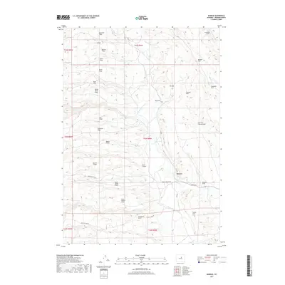
2017 Map of Barnum
USGS Topo · Published 2017About this map
Barnum occupies a central point in this high-plains landscape, where the confluence of managed water and complex terrain defines local settlement. The map reveals an intricate network of irrigation systems, including the Barnum Ditch, White Panther Ditch, and Blue Cr Ditch, which redirect water from the Red Fork Powder River and Beaver Cr to support agricultural life in the valley. These human-made channels contrast sharply with the surrounding topography, which is characterized by a series of prominent ridges and draws such as Wide Divide Ridge, Horse Pasture Ridge, and the deep Devoe Canyon. A long tradition of ranching and land use is evident in the naming of features like Buckbrush Butte and Poison Weed Ridge, while the presence of the Big Red Reservoir further highlights the critical importance of water management in Johnson County. This survey provides a clear view of the high-desert landscape as it functioned in the early twenty-first century.
Find a feature on this map
46 named features on this map. Tap any name to fly to it.
Don’t see what you’re looking for? This feature index may not catch every label — zoom into the map to look around manually.
Map Details
Editions of this 2017 Barnum Map
This is the sole edition of this map. No revisions or reprints were ever made.
Other maps of this area

1955 · Arminto
USGS Topo · 1:250,000

1958 · Arminto
USGS Topo · 1:250,000

1961 · Barnum
USGS Topo · 1:62,500

1962 · Arminto
USGS Topo · 1:250,000

1963 · Mayoworth
USGS Topo · 1:62,500
1967 · Tabletop
USGS Topo · 1:24,000

1967 · Gordon Creek
USGS Topo · 1:24,000

1967 · Turk Springs
USGS Topo · 1:24,000
1979 · Red Fork Powder River
USGS Topo · 1:24,000
1979 · Nowater Creek
USGS Topo · 1:100,000