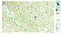
1982 Map of Barnwell
USGS Topo · Published 1984About this map
The Savannah River Plant Department of Energy dominates the western landscape of this early 1980s topographic map, a massive Cold War-era nuclear facility that reshaped the rural character of this region. Adjacent to the Savannah River, the site features man-made water bodies like Par Pond, L Pond, and R Pond which were integral to its industrial cooling processes. Surrounding this facility, the map shows a network of traditional South Carolina settlements including Barnwell, Allendale, and Bamberg.
Find a feature on this map
66 named features on this map. Tap any name to fly to it.
Don’t see what you’re looking for? This feature index may not catch every label — zoom into the map to look around manually.
Map Details
Editions of this 1982 Barnwell Map
This is the sole edition of this map. No revisions or reprints were ever made.
Other maps of this area

1892 · Mc Cormick
USGS Topo · 1:125,000

1912 · Mc Cormick
USGS Topo · 1:125,000

1918 · Varnville
USGS Topo · 1:62,500

1919 · Gough
USGS Topo · 1:62,500

1919 · Olar
USGS Topo · 1:62,500

1919 · Bamberg
USGS Topo · 1:48,000

1919 · Allendale
USGS Topo · 1:62,500

1919 · Cummings
USGS Topo · 1:62,500

1919 · Lodge
USGS Topo · 1:62,500

1920 · Ellenton
USGS Topo · 1:48,000