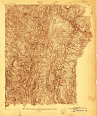
1922 Map of Barre
USGS Topo · Published 1922About this map
Norwich University stands at the heart of this survey of central Vermont, anchoring the town of Northfield during the early 1920s. The landscape is defined by the steep valleys of the Dog River and the Stevens Branch, where industry and institution overlap. To the east, the granite-rich hills of Websterville and Graniteville surround Millstone Hill, revealing the intensive quarrying operations that drove the local economy. The transportation network is dominated by the Central Vermont Ry, which follows the river corridors, connecting the industrial quarries and agricultural centers.
Find a feature on this map
129 named features on this map. Tap any name to fly to it.
Don’t see what you’re looking for? This feature index may not catch every label — zoom into the map to look around manually.
Map Details
Editions of this 1922 Barre Map
This is the sole edition of this map. No revisions or reprints were ever made.
Other maps of this area
1896 · Strafford
USGS Topo · 1:62,500
1915 · Rochester
USGS Topo · 1:62,500
1917 · Rochester
USGS Topo · 1:62,500
1919 · Royalton
USGS Topo · 1:62,500
1919 · Lincoln Mountain
USGS Topo · 1:62,500
1919 · Montpelier
USGS Topo · 1:62,500
1920 · Lincoln Mountain
USGS Topo · 1:48,000
1921 · Richmond
USGS Topo · 1:48,000
1921 · Lincoln Mountain
USGS Topo · 1:62,500
1921 · Montpelier
USGS Topo · 1:62,500