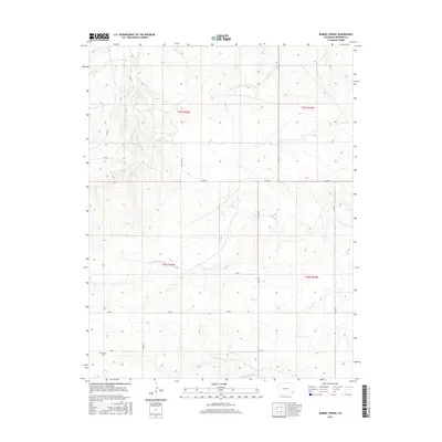
2016 Map of Barrel Spring
USGS Topo · Published 2016About this map
Bethel Cem sits in the southwestern corner of this landscape, a lone marker of local heritage within the grid of rural Prowers County. The terrain is defined by a dense network of intermittent watercourses that drain the High Plains, including the complex drainage system of N Plum Cr, Middle Plum Cr, and S Plum Cr. These ephemeral streams create a distinctive topographical pattern of ridges and draws across the eastern half of the survey. Essential water sources like Barrel Spring and Blackwater Spring are tucked along the banks of Wolf Cr, providing critical orientation points in a region where reliable water dictated early land use. A rigid framework of county roads, such as Co RD N and Co RD 19, bisects the natural drainage patterns, illustrating the ongoing intersection of modern infrastructure and the primary landscape.
Find a feature on this map
22 named features on this map. Tap any name to fly to it.
Don’t see what you’re looking for? This feature index may not catch every label — zoom into the map to look around manually.
Map Details
Editions of this 2016 Barrel Spring Map
This is the sole edition of this map. No revisions or reprints were ever made.
Other maps of this area

1891 · Albany
USGS Topo · 1:125,000

1892 · Two Butte
USGS Topo · 1:125,000

1893 · Two Butte
USGS Topo · 1:125,000

1893 · Albany
USGS Topo · 1:125,000

1955 · La Junta
USGS Topo · 1:250,000

1958 · La Junta
USGS Topo · 1:250,000

1968 · La Junta
USGS Topo · 1:250,000
1968 · North Plum Creek NE
USGS Topo · 1:24,000
1968 · Cat Creek NE
USGS Topo · 1:24,000
1968 · North Plum Creek SE
USGS Topo · 1:24,000