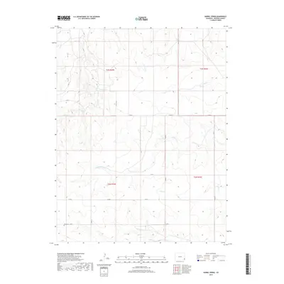
2019 Map of Barrel Spring
USGS Topo · Published 2019About this map
Bethel Cem sits in the southwestern corner of this Colorado landscape, marking a site of local genealogical significance within a terrain defined by its complex drainage network. The area is a mosaic of seasonal creek beds and springs that flow through the High Plains. Essential water sources such as Barrel Spring and Blackwater Spring are vital landmarks in this arid environment, while the branching system of N Plum Cr, Middle Plum Cr, and S Plum Cr illustrates the hydrological pattern of the region. A series of numbered county roads, including Co RD 15 and Co RD N, create a rigid grid that segments the land into the Public Land Survey System townships of t25s r45w and t26s r44w, showing how 21st-century agricultural and property boundaries remain dictated by historical surveying.
Find a feature on this map
22 named features on this map. Tap any name to fly to it.
Don’t see what you’re looking for? This feature index may not catch every label — zoom into the map to look around manually.
Map Details
Editions of this 2019 Barrel Spring Map
This is the sole edition of this map. No revisions or reprints were ever made.
Other maps of this area

1891 · Albany
USGS Topo · 1:125,000

1892 · Two Butte
USGS Topo · 1:125,000

1893 · Two Butte
USGS Topo · 1:125,000

1893 · Albany
USGS Topo · 1:125,000

1955 · La Junta
USGS Topo · 1:250,000

1958 · La Junta
USGS Topo · 1:250,000

1968 · La Junta
USGS Topo · 1:250,000
1968 · North Plum Creek NE
USGS Topo · 1:24,000
1968 · Cat Creek NE
USGS Topo · 1:24,000
1968 · North Plum Creek SE
USGS Topo · 1:24,000