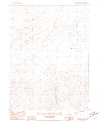
1981 Map of Barrett Springs
USGS Topo · Published 1982About this map
Barrett Springs and its namesake Barrett Springs Well anchor this high-desert landscape in the late 1970s. The terrain is defined by the shifting geography of the Crescent Dunes and extensive Sand Dune fields that give way to the Silver State Valley and an expansive Alkali Flat. Evidence of transit history is preserved through the Old Stage Road Historical, including a Portion of Old Stage Rd. that cuts across the arid flats. This provisional survey captures a moment when the regional economy focused on mineral extraction, marked by an Open Pit Mine and a Gravel Pit near the springs. The rugged southern topography is dominated by the Tenmile Hills and Krum Hills, providing a stark contrast to the open basin where isolated Windmills serve as critical water infrastructure for this remote Nevada interior.
Find a feature on this map
14 named features on this map. Tap any name to fly to it.
Don’t see what you’re looking for? This feature index may not catch every label — zoom into the map to look around manually.
Map Details
Editions of this 1981 Barrett Springs Map
This is the sole edition of this map. No revisions or reprints were ever made.
Other maps of this area

1882 · Paradise
USGS Topo · 1:250,000

1886 · Disaster
USGS Topo · 1:250,000

1893 · Paradise
USGS Topo · 1:250,000

1893 · Disaster
USGS Topo · 1:250,000

1931 · Lovelock
USGS Topo · 1:250,000

1932 · Sonoma Range
USGS Topo · 1:250,000

1935 · Lovelock
USGS Topo · 1:250,000

1939 · Sonoma Range
USGS Topo · 1:250,000

1954 · Vya
USGS Topo · 1:250,000

1955 · McDermitt
USGS Topo · 1:250,000