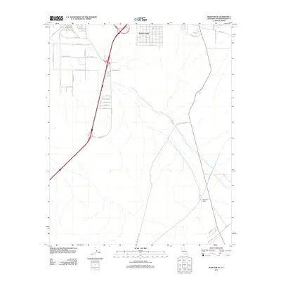
2012 Map of Barstow SE
USGS Topo · Published 2012About this map
Lenwood and the developing residential grid of Barstow Heights anchor this high-desert landscape during the early twenty-first century. The map illustrates a transitional suburban-desert interface where modern thoroughfares like Veterans Pkwy and Stoddard Wells Rd cut through the open expanses of Stoddard Valley. Named desert roads such as Salamander Blvd, Tortoise Rd, and Gerrymander Rd suggest the planned growth of the area south of the city core. This survey serves as a precise record of the infrastructure and land-use patterns in San Bernardino County, capturing the specific street layouts of Arbuckle ST and Corning Ave before further desert development. The vastness of the valley floor is punctuated only by utility corridors like Pipeline Rd, reflecting the logistical importance of this Mojave corridor.
Find a feature on this map
47 named features on this map. Tap any name to fly to it.
Don’t see what you’re looking for? This feature index may not catch every label — zoom into the map to look around manually.
Map Details
Editions of this 2012 Barstow SE Map
This is the sole edition of this map. No revisions or reprints were ever made.
Other maps of this area

1932 · Barstow
USGS Topo · 1:125,000

1934 · Barstow
USGS Topo · 1:125,000

1953 · San Bernardino
USGS Topo · 1:250,000
1953 · Nebo
USGS Topo · 1:24,000

1955 · Ord Mountains
USGS Topo · 1:62,500

1956 · San Bernardino
USGS Topo · 1:250,000

1956 · Daggett
USGS Topo · 1:62,500

1956 · Barstow
USGS Topo · 1:62,500

1957 · Apple Valley
USGS Topo · 1:62,500

1957 · San Bernardino
USGS Topo · 1:250,000