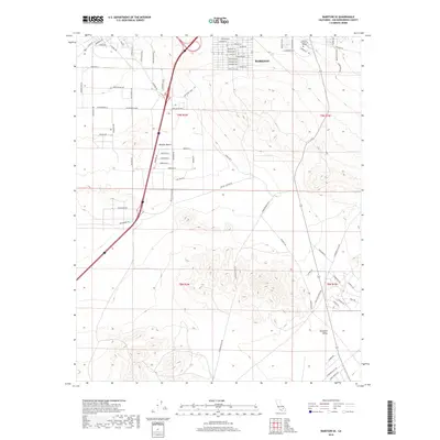
2018 Map of Barstow SE
USGS Topo · Published 2018About this map
Barstow expansion in the modern era is evident in this topographic survey, which highlights the intersection of academic, industrial, and desert landscapes. The campus of Barstow Community College stands out on the northern edge, situated near the transition from urban infrastructure to the open expanse of the Mojave Desert. The area south of the main city shows a network of named roads like Salamander Blvd and Tortoise Rd, reflecting local environmental themes in the residential and commercial planning of San Bernardino County. Further south, the map transitions into the broad terrain of Stoddard Valley, where the landscape is defined more by its natural contours than by the dense street grids found near W Main St. The presence of Industrial Way and Commerce Pkwy underscores the logistics-driven economy that defines this high-desert hub.
Find a feature on this map
83 named features on this map. Tap any name to fly to it.
Don’t see what you’re looking for? This feature index may not catch every label — zoom into the map to look around manually.
Map Details
Editions of this 2018 Barstow SE Map
This is the sole edition of this map. No revisions or reprints were ever made.
Other maps of this area

1932 · Barstow
USGS Topo · 1:125,000

1934 · Barstow
USGS Topo · 1:125,000

1953 · San Bernardino
USGS Topo · 1:250,000
1953 · Nebo
USGS Topo · 1:24,000

1955 · Ord Mountains
USGS Topo · 1:62,500

1956 · San Bernardino
USGS Topo · 1:250,000

1956 · Daggett
USGS Topo · 1:62,500

1956 · Barstow
USGS Topo · 1:62,500

1957 · Apple Valley
USGS Topo · 1:62,500

1957 · San Bernardino
USGS Topo · 1:250,000