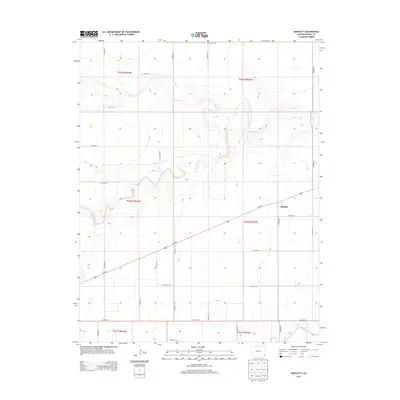
2013 Map of Bartlett
USGS Topo · Published 2013About this map
The high plains of Baca County are defined by a rhythmic grid of rural routes and intermittent drainages, centered on the small settlement of Bartlett. This landscape is primarily shaped by the east-west corridor of Us-160 E, which serves as the primary artery for the region. The drainage patterns of Horse Creek and Bear Creek cut through the terrain, creating localized relief in an otherwise strictly surveyed section-line landscape. These seasonal watercourses, including Muddy Creek and Sand Arroyo Cr, indicate the subtle topographical shifts that dictate local land use. The extensive network of county roads, such as Co Road 48 and Co Road 52, provides a clear view of the agricultural organization and property boundaries established by the Public Land Survey System during this era of early 21st-century Colorado history.
Find a feature on this map
31 named features on this map. Tap any name to fly to it.
Don’t see what you’re looking for? This feature index may not catch every label — zoom into the map to look around manually.
Map Details
Editions of this 2013 Bartlett Map
This is the sole edition of this map. No revisions or reprints were ever made.
Other maps of this area

1891 · Albany
USGS Topo · 1:125,000

1892 · Vilas
USGS Topo · 1:125,000

1893 · Albany
USGS Topo · 1:125,000

1955 · La Junta
USGS Topo · 1:250,000

1958 · La Junta
USGS Topo · 1:250,000

1968 · La Junta
USGS Topo · 1:250,000
1971 · Lycan SE
USGS Topo · 1:24,000

1971 · Two Buttes SE
USGS Topo · 1:24,000
1971 · Lycan
USGS Topo · 1:24,000

1978 · Walsh SE
USGS Topo · 1:24,000