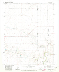
1971 Map of Lycan SE
USGS Topo · Published 1973About this map
Colorado and Kansas meet along this state line survey, where the drainages of the High Plains cut through the landscape of Baca and Stanton counties. This terrain is defined by the intermittent flow of high-plains waterways, with Beaty Creek and Buffalo Creek carving shallow paths across the border. The reliance on groundwater in this arid region is evident by the placement of isolated water sources such as the Spring and Well located near the southern portion of the quadrangle. Most of the map area is characterized by the open range of Manter, showing a transition from the agricultural plains into more broken creek bottomlands. To the southeast, the larger drainage of Bear Creek begins to broaden, marking a significant topographical feature in an otherwise uniform landscape of section lines and range boundaries established during this early 1970s field check.
Find a feature on this map
8 named features on this map. Tap any name to fly to it.
Don’t see what you’re looking for? This feature index may not catch every label — zoom into the map to look around manually.
Map Details
Editions of this 1971 Lycan SE Map
This is the sole edition of this map. No revisions or reprints were ever made.
Other maps of this area

1891 · Albany
USGS Topo · 1:125,000

1892 · Vilas
USGS Topo · 1:125,000

1893 · Albany
USGS Topo · 1:125,000

1900 · Syracuse
USGS Topo · 1:125,000

1920 · Syracuse
USGS Topo · 1:125,000

1955 · La Junta
USGS Topo · 1:250,000

1955 · Dodge City
USGS Topo · 1:250,000

1958 · La Junta
USGS Topo · 1:250,000

1958 · Dodge City
USGS Topo · 1:250,000

1959 · Dodge City
USGS Topo · 1:250,000