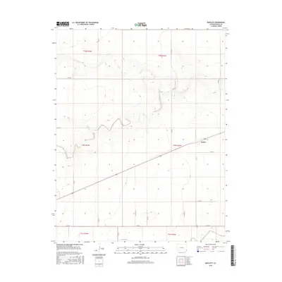
2016 Map of Bartlett
USGS Topo · Published 2016About this map
Bartlett sits at a crossroads in the eastern plains of Colorado, serving as the primary hub for a landscape defined by an extensive grid of section-line roads and seasonal watercourses. The local hydrology is dominated by ephemeral drainage systems including Horse Cr, Muddy Cr, and Bear Creek. These creeks wind through the township ranges of the high plains, providing natural relief to the otherwise geometric layout of the county road network. The map reveals a highly structured agricultural or grazing environment where named routes like Co RD 47 and Co RD KK facilitate movement between distant homesteads. In the southern reaches, Sand Arroyo Creek cuts across the terrain, illustrating the gradual descent of the watershed toward the southeast. This 2016 survey highlights the enduring rural character of the region, where a single town remains the focal point of community life amidst the vast expanse of the Baca County prairie.
Find a feature on this map
27 named features on this map. Tap any name to fly to it.
Don’t see what you’re looking for? This feature index may not catch every label — zoom into the map to look around manually.
Map Details
Editions of this 2016 Bartlett Map
This is the sole edition of this map. No revisions or reprints were ever made.
Other maps of this area

1891 · Albany
USGS Topo · 1:125,000

1892 · Vilas
USGS Topo · 1:125,000

1893 · Albany
USGS Topo · 1:125,000

1955 · La Junta
USGS Topo · 1:250,000

1958 · La Junta
USGS Topo · 1:250,000

1968 · La Junta
USGS Topo · 1:250,000
1971 · Lycan SE
USGS Topo · 1:24,000

1971 · Two Buttes SE
USGS Topo · 1:24,000
1971 · Lycan
USGS Topo · 1:24,000

1978 · Walsh SE
USGS Topo · 1:24,000