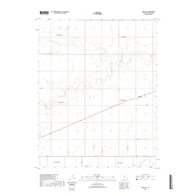
2019 Map of Bartlett
USGS Topo · Published 2019About this map
The high plains of Southeast Colorado are defined by a network of ephemeral watercourses and section-line roads in this 2019 survey. The small settlement of Bartlett serves as a focal point along a primary transit corridor, surrounded by an expansive grid of agricultural land. The terrain is marked by the winding paths of Bear Creek, Horse Cr, and Muddy Cr, which have carved subtle drainage patterns across the landscape. The Public Land Survey System grid is clearly visible here, with township and range lines such as t30s r42w and t31s r43w organizing the territory into the traditional squares of the American West. In the southern reaches, the Sand Arroyo Creek cuts through the corners of the grid, providing a distinct geological contrast to the straight paths of county roads like Co RD 50 and Co RD 47.
Find a feature on this map
27 named features on this map. Tap any name to fly to it.
Don’t see what you’re looking for? This feature index may not catch every label — zoom into the map to look around manually.
Map Details
Editions of this 2019 Bartlett Map
This is the sole edition of this map. No revisions or reprints were ever made.
Other maps of this area

1891 · Albany
USGS Topo · 1:125,000

1892 · Vilas
USGS Topo · 1:125,000

1893 · Albany
USGS Topo · 1:125,000

1955 · La Junta
USGS Topo · 1:250,000

1958 · La Junta
USGS Topo · 1:250,000

1968 · La Junta
USGS Topo · 1:250,000
1971 · Lycan SE
USGS Topo · 1:24,000

1971 · Two Buttes SE
USGS Topo · 1:24,000
1971 · Lycan
USGS Topo · 1:24,000

1978 · Walsh SE
USGS Topo · 1:24,000