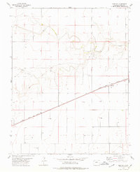
1978 Map of Bartlett
USGS Topo · Published 1979About this map
Bartlett sits at a literal and metaphorical crossroads in the late 1970s, where the steel of the Atchison Topeka and Santa Fe railroad cuts a straight line through the high plains of Baca County. This landscape is defined by its water management and agricultural infrastructure, evidenced by the numerous marked wells scattered across the township grid. The drainage patterns of Horse Creek, Bear Creek, and Muddy Creek suggest a terrain carved by seasonal flows, while the small settlement of Fenix marks a secondary node of activity along the rail corridor. For researchers of Colorado’s southeastern corner, this document captures the sparse but organized settlement pattern required to sustain life and industry in a semi-arid environment during the mid-to-late 20th century.
Find a feature on this map
8 named features on this map. Tap any name to fly to it.
Don’t see what you’re looking for? This feature index may not catch every label — zoom into the map to look around manually.
Map Details
Editions of this 1978 Bartlett Map
This is the sole edition of this map. No revisions or reprints were ever made.
Other maps of this area

1891 · Albany
USGS Topo · 1:125,000

1892 · Vilas
USGS Topo · 1:125,000

1893 · Albany
USGS Topo · 1:125,000

1955 · La Junta
USGS Topo · 1:250,000

1958 · La Junta
USGS Topo · 1:250,000

1968 · La Junta
USGS Topo · 1:250,000
1971 · Lycan SE
USGS Topo · 1:24,000

1971 · Two Buttes SE
USGS Topo · 1:24,000
1971 · Lycan
USGS Topo · 1:24,000

1978 · Walsh SE
USGS Topo · 1:24,000