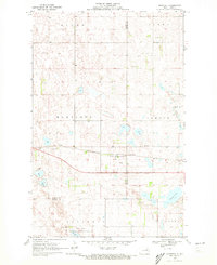
1970 Map of Bartlett
USGS Topo · Published 1972About this map
Bartlett stands as the primary hub of this prairie landscape during the late 1960s, situated along the Burlington Northern railroad line. The map illustrates a region defined by its numerous small water bodies and glacial depressions, including Twin Lakes and Jones Lake. A significant portion of the southern terrain is dedicated to the Rose Lake National Wildlife Refuge, which encompasses the waters of Rose Lake. The survey also documents the local infrastructure of the era, noting several Gravel Pits and a local Cem near the town site. Crossing the southern portion of the map is the boundary between Ramsey Co and Nelson Co, providing a clear view of how these county lines intersected with rural townships like Nixon, Clara, and Lakota.
Find a feature on this map
15 named features on this map. Tap any name to fly to it.
Don’t see what you’re looking for? This feature index may not catch every label — zoom into the map to look around manually.
Map Details
Editions of this 1970 Bartlett Map
This is the sole edition of this map. No revisions or reprints were ever made.
Other maps of this area

1930 · Pekin
USGS Topo · 1:62,500

1930 · Hamar
USGS Topo · 1:62,500

1950 · Devils Lake Mountain
USGS Topo · 1:24,000

1951 · Pekin NE
USGS Topo · 1:24,000

1951 · Devils Lake Mountain
USGS Topo · 1:24,000

1951 · Pekin NW
USGS Topo · 1:24,000

1951 · Pekin
USGS Topo · 1:62,500

1952 · New Rockford
USGS Topo · 1:250,000

1953 · Devils Lake
USGS Topo · 1:250,000

1956 · New Rockford
USGS Topo · 1:250,000